Geology is history. The history of the earth. In the table mountain landscape, we find geological sites and phenomena that only exist here, or in a few places in the world. Here you can travel in time — several million years. Each place is a piece of the puzzle, which together tell a story that begins 1700 million years ago.
All around the globe, the continents of the earth are in constant movement. Our planet’s surface is made up of moving tectonic plates which can collide or slide underneath each other, resulting in volcanic eruptions. This is how oceans are born and die, how mountain ranges are built up and break down. It all takes very long time, of course – millions of years.
In West Sweden, tectonic plates have collided and joined with an older plate to the east several times. The various rocks found in Platåbergens Geopark have formed deep within the earth but also at shallow depths, in connection to volcanic eruptions. There are also rocks here formed from sediment, which have become pressed together under high pressure and high temperatures, transforming them into stone.
Earth’s continents are in constant movement around the globe. Our planet’s outer layer consists of plates that move and can collide or slide beneath each other, resulting in earthquakes and volcanic eruptions. This is how oceans are born and die, how mountain ranges are created and worn down. Of course, this all happens across very long periods of time – millions of years. West Sweden has seen several plate collisions where plates have merged with an older continental crust to the east. Some of the rocks in Platåbergens Geopark have formed deep down inside the earth, and some have formed closer to the earth’s crust. But we can also find rocks formed from sediment, which became exposed to high pressure and temperatures and thus turned to stone.
Platåbergens Geopark contains geological phenomena and sites that are unique to this area or can only be found in few places around the world. Its geological history stretches 1,700 million years into the past! The following phenomena are of special international interest:
- The peneplain
- The table mountains
- Quaternary geology and ice age deposits.
The Swedish name Platåbergen literally means “the Plateau Mountains”.
Milestones in the geological history of the table mountain landscape
- 20,000–11,700 years: the ice sheet begins to withdraw. The Baltic Ice Lake is drained in two cataclysmic events.
- 115,000 years: the latest ice age begins and reshapes the landscape yet again.
- 250 million years and onwards: the sedimentary rocks erode, leaving only those areas covered by the dolerite.
- 280 million years: magma from inside the earth rises and penetrates the sedimentary rocks in some places, creating the rock known as dolerite.
- 540 million years: the sea covers the peneplain. Sediment is deposited on top of the peneplain, eventually becoming the sedimentary rocks in the table mountains.
- 600 million years: the bedrock erodes and eventually becomes a peneplain.
- 1,700 million years: formation of the basement rock.
The oldest bedrock, the mylonite zone, and the peneplain
Did you know that the oldest rock types found in Platåbergens Geopark formed 1.7 billion years ago? That is such an incredibly long perspective compared to human history that we struggle to understand it … The oldest rocks formed before there were any advanced life forms on Earth – no soil, no trees, no animals. The rocks were thus extremely exposed to a lot of stress from the weather, and over 600 million years they were eroded down to a completely flat surface – the peneplain. Whenever you walk on the peneplain, you are transported back in time to Earth as it was before life.
The basement rock
The area around Platåbergen in the province of Västergötland sits on top of the basement rock, a part of the earth’s crust that formed approximately 1.7–1.65 billion years ago. At this time, two tectonic plates met and hot, melted rock (magma) emerged from within the earth, forming the first bedrock in Platåbergens Geopark. It was made up of granite, but the long and violent history that this granite has endured has caused it to partly be transformed into various forms of gneiss. Because of their distinct appearance, we say that the gneisses are foliated and banded.
Some types of granite in the geopark are different from the 1.7‑billion-year-old foliated and banded gneisses that make up the oldest bedrock. These younger rocks formed approximately 1.3 billion years ago when magma penetrated the older bedrock and congealed deep within it. These rocks have not had to endure the same events which deformed and transformed the older bedrock into the banded gneisses we can see today. Thus, these younger granites look less deformed than the gneisses. There is some banding in the younger granites, however, but that is the result of a collision with the North American tectonic plate approximately 1 billion years ago.
The mylonite zone
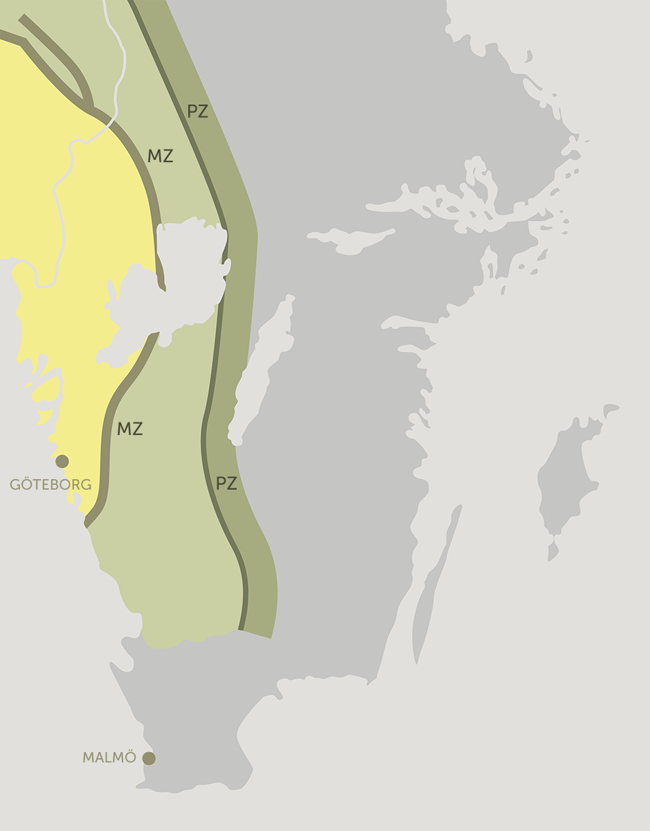
Due to the movements in the earth’s crust, continents have collided and separated several times in the area that is known today as Västergötland. The processes which affect the landscape and the rocks in the area are massive in scale and immensely powerful. One event had an especially strong impact on the geopark’s oldest bedrock: the collision with the North American tectonic plate, which took place approximately 1 billion years ago. Large chunks of the bedrock were pushed in an easterly direction, almost doubling the thickness of the earth’s crust to the east. Because of the weight of the projecting bedrock, the underlying part of the crust was pushed downwards deep into the earth, where the rock was heated up and transformed. One area where this took place was along the so-called mylonite zone, an area which can be followed through the geopark in a north-south direction.
When the bedrock was pushed together, it resulted in the formation of a tall mountain range. As the plates begun to move apart again approximately 970 million years ago, the mountain range collapsed. The projecting bedrock then slid back westwards (along the mylonite zone, for example) and the crust, which had been pressed down, rose back up, weathered and eventually regained its normal thickness. Thus, the surface we walk on in the geopark today was once located at a depth of several kilometres. The sediment which formed from the weathered mountain range, as it rose up after being rid of the weight of the projecting bedrock, can today only be found scattered far outside the area of the geopark.
The peneplain
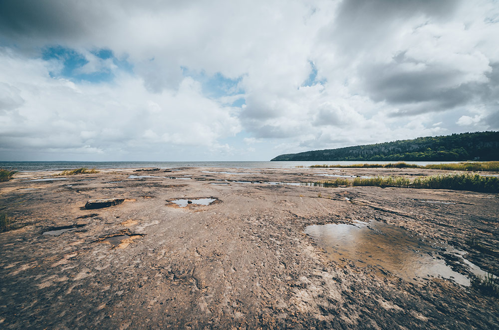
A little over 600 million years ago, a global cooling of the earth’s crust resulted in major glaciations. This event was followed by a climate which promoted heavy erosion of the bedrock. The landscape eroded to an even surface and large, flat areas formed, which are called peneplains. The peneplain in the geopark is known as the “sub-Cambrian peneplain”, since it formed before the Cambrian Period and is thus situated beneath the Cambrian sedimentary rocks in Platåbergen.
The peneplain formed over large parts of Sweden and this ancient basement rock surface can be seen in several places around the geopark. What we today know as Västgötaslätten (the Västergötland plain) is in fact part of this weathered basement rock surface.
The table mountains
Around 500 million years ago, our continent was situated south of the equator. In this environment, sediment formed on the bottom of a sea – sand, lime and clay. These sediments later became stone building the table mountains. The soft, sedimentary rocks have been preserved thanks to a protective cover made up of the much harder rock known as dolerite.
The layers of rock seen in Platåbergen are a window into the geological period known as the Palaeozoic (541 to 251 million years ago). The rocks here bear silent witness to several geological processes which are important for understanding our planet’s development. For example, both fossils of extinct species and some of the oldest meteorite finds in the world can be found here, in the table mountains of Västergötland.
The supercontinent which had formed 1 billion years ago, containing more than Northern Europe and North America, split apart again approximately 600 million years ago. An ocean, known as the Iapetus Ocean, formed between the North American continent and Northern Europe. Sand particles and calcium-rich sediment were deposited in the ocean, which itself was rich in aquatic organisms – something that we can see today in the form of fossils in the different layers of Platåbergen.
As the gap between North America and Northern Europe widened, the ocean expanded. Clay particles were deposited on top of the sand along with remains of dead organisms. The sand particles later became sandstone, and the clay deposited on the ocean floor was the origin of the rock type that we know as alum shale.
During the Ordovician Period, the seafloor spreading ceased and North America and Northern Europe once again began to move closer together. Large quantities of calcium-rich sediment were deposited in the Iapetus Ocean, sediment which would eventually become limestone. This type of limestone has been mined in Hällekis in Västergötland and is known in Sweden as Ortocer limestone.
When the North American plate moved closer to the equator, the Iapetus Ocean continued to shrink and at the end of the Silurian Period (approximately 400 million years ago), North America collided with the Northern European plate. This event caused the formation of the fells, or the Scandinavian Caledonides. Residual sediment from this shrinking ocean has been preserved as a top layer of dark shale, for example at Kinnekulle.
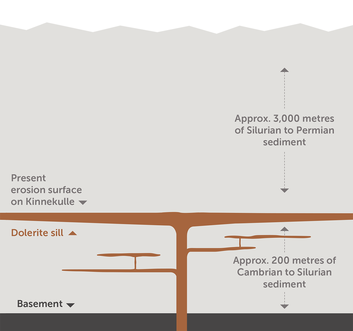
At the end of the Carboniferous Period (approximately 358 to 298 million years ago), the earth’s crust ruptured in the area where the Norwegian capital Oslo is now situated, which resulted in significant volcanic activity. This volcanic activity lasted for tens of millions of years and could also be felt in what is now West Sweden. Inside the thick layers of sediment which covered the geopark area, dark magma emerged, rich in iron and magnesium. When the magma reached the upper part of the crust, it seeped in along the horizontal sediment layers and congealed, forming “passages” of dolerite. The relatively soft sedimentary rocks covering the dolerite eroded quickly and can today be found elsewhere, for example in the Baltic Sea. Thus, the hard dolerite was exposed and today we can see it at the top of the table mountains.
Here’s a jingle to remember the rock layers in the mountains. “USA KLockan Tre” (“USA three o’clock”) stands for the Swedish names of the rocks in the correct order: bedrock, sandstone, alum shale, limestone, clay shale and dolerite.
When the magma reached the upper part of the crust, it seeped in along the horizontal sediment layers and congealed, forming “passages” of dolerite.
Quaternary geology
The table mountains in Västergötland have partly been eroded down to their current shape due to several glaciations which have occurred since the mountains formed. The present-day landscape is largely characterised by deposits and formations created during the last ice age, which began 115,000 years ago. When the ice was at its thickest, the geopark area was covered by an ice sheet approximately 3.5 kilometres thick. As the climate became warmer approximately 20,000 years ago, the ice began to retreat northwards (having reached as far south as the area around present-day Berlin in Germany) and Sweden gradually became ice free.
During the melting of the ice, several dramatic events took place in the geopark area. A huge meltwater lake – the Baltic Ice Lake – was drained twice into the Western Sea through a passage directly north of Billingen. Furthermore, between these drainage events, an abrupt cooling of the climate lasting more than a thousand years caused the ice to grow back again.
The first drainage occurred when the ice retreated, leaving a passage directly north of Billingen through which the Baltic Ice Lake, a dammed-up lake situated roughly where the Baltic Sea is today, was drained in a cataclysmic event.
The climate abruptly cooled down shortly after the first drainage and in a matter of years temperatures were the same as during the ice age. This period is known as the Younger Dryas (approximately 12,800–11,600 years ago). The cold climate caused the ice to grow back, and the ice edge again moved south in the area of the geopark. Large quantities of glacial till, in the form of boulders and rocks, were deposited in front of the ice edge, creating what we know as Hindens rev and Hjortens udde (“Reef of the Hind” and “Stag Point”). These are part of the so-called Mid-Swedish Edge Zone, along with Råda Ås, Skararyggen, and several other ridges.
The next major event was the second sudden drainage of the Baltic Ice Lake, which took place when the ice that had formed during the Younger Dryas began to melt. The ice edge again retreated to the north end of Billingen. Then, in a sudden cataclysm approximately 11,700 years ago, the meltwater from the ice lake broke trough the glacial edge and flooded the plains below. The Baltic Ice Lake, which contained huge quantities of meltwater, had grown as the ice edge retreated northwards. Since the ice lake was situated 25 metres above sea level, the water was drained westwards into the North Atlantic. Calculations show that 7,500 km3 of water rushed through the landscape! It took almost a year for all the water to drain from the Baltic Ice Lake to sea level, but eventually a continuous sea formed – the Yoldia Sea.
The geological history of the geopark can also be seen in the composition of the various soil types. Areas in the north and northwest, which were once below the sea, are dominated by clay and other fine-grained soil types, while areas in the southeast are made up of moraines, where eroded shale from the table mountains contribute to make the soil fertile. In some places with a limestone bedrock the soil cover is very thin. This type of land is the same as the alvar in Öland and it makes for extreme farming conditions.


